Questions
You can make your donation here if you have found this chapter useful.
This section contains a number of self-test questions on the material in Chapter 3 Charts & Navigational Aids. For ease of use / reference, the questions are listed under the section heading where you (should have) learned to answer them! Click on the heading to go to that section.
If you click on the question itself, the answer should appear in a pop-up message, provided your browser allows such things (sometimes excluded as a security measure). So if that doesn't work, have a look at the end of the page.
Some questions involve the use of a chart, so we have chosen Admiralty Leisure Folio "The Solent and Approaches" - because this Folio will be useful for a lot of people to own. The questions are set so that any equivalent charts will work, but for positions note that the Chart Datum is WGS 84.
1 True or false? Small-scale charts cover large areas, large-scale charts cover small areas.
2 A chart scale is stated as 1 : 150,000. Approximately how many nautical miles is represented by 1 cm on the chart? What is the easiest way to check this, and why in practice would you never bother with this calculation?
3 What feature of Mercator or Transverse Mercator projections makes them convenient for navigation?
4 True or false? The scale is the same all over a small scale Mercator projection chart.
5 True or false? When crossing an ocean, the shortest distance is a straight line on a Mercator projection chart.
6 True or false? Most UK Admiralty charts are produced to WGS 84 Datum, which is the normal default datum for GPS.
7 True or False? You should set your GPS to the chart datum for the particular chart you are using, otherwise positions plotted from the GPS onto the chart (and positions taken from the chart and entered into the GPS) will be in error.
8 You are using a chart to navigate round a remote island in the Caribbean, based on a very old survey. Which is the safest for avoiding dangers: carefully plotting you position from GPS, or position fixing from charted landmarks? What else should you do when approaching shallow areas?
1 You are navigating towards an unfamiliar port using a small-scale chart for the passage. You get out a large-scale chart of the immediate approaches to the port, to decide how to tackle the pilotage into your destination. What is the first thing you should check when looking at the large-scale chart?
2 Refer to chart 5600.4 which shows the area 1 mile to the north-east of Hurst Point. You are in a yacht with 1.5m draught - you want to anchor for lunch, to wait for the tide to turn in your favour at low water. Without checking the tidal heights, is it OK to anchor in the area marked dark blue?
3 Can you anchor in the area marked light blue? What do you expect the holding to be like?
4 Refer to 5600.17. What height of tide do you require to reach Keyhaven YC?
5 You are in the western Solent using chart 5600.6. What landmarks do you think might be helpful for a position fix?
6 Refer to 5600.4. You have sailed down to the Needles on a sunny day with a cool breeze from the north. Someone suggests anchoring under the cliffs just south of West High Down for lunch. Do you think this is a good idea?
7 The same person advises Colwell Bay for tea on the way home. Is this OK?
8 Why do you think you should take care entering the Needles Channel in heavy weather?
9 Have you bought Chart 5011 yet? Why not?
1 You are heading north west, up the side of a shipping channel, in the dark. You have about 5 miles to run to your destination. Ahead of you is a white light flashing 3 every 10s: you recognise this as an East Cardinal, meaning "clear water to the east". Should you alter course to pass to the east side of it?
2 In the UK, Europe, Mediterranean etc (not USA) channels are marked with red and green lateral marks. In which direction should you keep red marks to port when following the channel?
3 True or false? It is compulsory to keep within a channel marked by red and green lateral marks in all UK harbours.
4 True or false? Red and green marks are the opposite way round in the USA.
5 A north cardinal mark indicates a danger: on which side of the buoy or beacon is the danger that it indicates?
6 Identify the following:
a) 
b) ![]()
c) 
d) 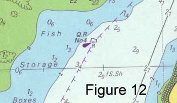
e) 
f) 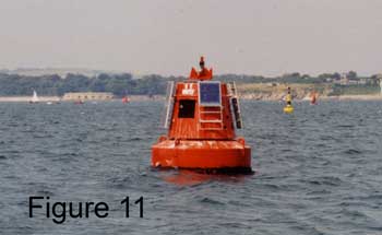
g) 
h) 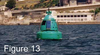
i) 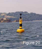
7 At night you see a white light, flashing six times followed by a long flash. Next to it is a white light flashing nine times. What are they?
8 You see continuous green flashing ahead of you. What kind of mark is it, and what light characteristics will you look for when you try to identify it on the chart?
9 The following are the light characteristics for St Catherine's Point Light:
Fl.5s41m26M & F.R.35m13M
Decode this.
10 Needles Light has the following characteristics:
Oc(2)WRG.20s24m17-13M
Decode this.
Answers
About Charts: 1 True, and if you memorise this it's probably the easiest way to remember which way round it is; 2 150,000 cm, which is 1.5km, or approx 0.8 nautical miles (1 nm = 1852m). To check, put a ruler against the latitude scale on the side of the chart (e.g. on chart 5600.1). In practice you just use the latitude scale to measure off nautical miles (1nm is one minute of latitude); 3 Straight lines are constant true bearings or directions; 4 False. The scale varies with latitude; 5 Generally False. The only straight lines which are also Great Circles (the shortest distance) are due North/South; 6 True - but you may still come across older or non-UK charts drawn to other datums; 7 True. The size of the error will depend on the chart datum and the (incorrect) datum the GPS is set to; and the error will be more significant when working with large scale charts; 8 Position fixing from landmarks, because this is how the chart was drawn in the first place. Latitude and longitude may be highly unreliable.
Admiralty Charts: 1 The scale - by looking at the scale of latitude on the side of the chart. This will enable you to visualise the area represented on the chart, and start to decide on your pilotage plan; 2 No. You may go aground at low water (this area is less than 2m LAT); 3 Yes - the light blue area is between 2m and 5m LAT so it should be OK at all states of the tide. The holding may not be good: G.bkSh.Wd stands for gravel; broken shells; weed (including Kelp); 4 From the chart the least depth seems to be just north of Keyhaven Lake - 0.1m drying height. So you need a height of tide of at least 1.6m to float there. The channel seems very narrow (< 20m) approaching Keyhaven, with drying heights of over 1m to either side. Seek advice from the YC; 5 On the north side: a 44m monument at Walhampton; a tower at St Leonard's Farm W of Beaulieu River; Old Coastguard Cottages just W of Beaulieu River; and not much else, maybe the 2 houses and various navigation aid beacons to the east of Beaulieu River. On the south side: Fort Victoria W of Yarmouth; church tower in Yarmouth; flagpole and lookout on 40m Shepheards Hill E of Newtown River; 6 No - there are numerous dangerous rocks close to the coast, and further off it may be too deep to anchor; 7 There are various dangers in this bay too, but if you approach with caution, keeping the Hotel on a bearing of approx 298°T, you should be able to anchor safely; 8 There are extensive tidal overfalls marked, extending W of Needles Point, and a warning in the Notes headed OVERFALLS; 9 There is no excuse!
Navigational Aids: 1 If you do, you will go aground after you pass it. You are in Calshot Reach (chart 5600.8), heading for Southampton, and you are observing the east cardinal beacon on Hamble Spit. The correct answer is "I don't know", because until you have identified the mark on the chart, you don't; 2 In the direction of the flooding tide, or into harbour; in the direction indicated by special symbol on the chart when this is not obvious; 3 False. In some cases it may be compulsory for small vessels to keep OUT of a marked channel which is intended for large vessels; 4 True; 5 On the south side; 6 a) South Cardinal b) Isolated Danger c) East Cardinal d) Port-hand Lateral e) North Cardinal f) Port-hand Lateral g) Safe Water h) Starboard-hand Lateral i) West Cardinal; 7 The first is a South Cardinal, and the second a West Cardinal; 8 It is a starboard-hand lateral mark. Look for Fl.G. or Q.G. or VQ.G. depending on the frequency of the flashing; 9 Single flash every 5 seconds, elevation of light 41 metres above MHWS, nominal range of light 26 nautical miles (the light will be white, as its colour is not mentioned); AND fixed red at elevation 35 metres with nominal range of 13 nautical miles. The chart shows the sectors in which each of these lights can be observed; 10 Occulting twice (meaning ON for most of the time and going OFF twice) colours white, red and green in sectors (which are marked on the chart); occulting pattern repeats every 20 seconds; elevation of light 24 metres above MHWS, nominal range of lights from 17 to 13 nautical miles depending on colour.