Questions
You can make your donation here if you have found this chapter useful.
This section contains a number of self-test questions on the material in Chapter 2 Tides. For ease of use / reference, the questions are listed under the section heading where you (should have) learned to answer them! Click on the heading to go to that section.
If you click on the question itself, the answer should appear in a pop-up message, provided your browser allows such things (sometimes excluded as a security measure). So if that doesn't work, have a look at the end of the page.
1 True or false? The sun has a greater effect on tides than the moon, because the sun has a greater mass than the moon.
2 True or false? The sun has no effect on tides, they are purely caused by the moon.
3 The typical pattern of tides is semi-diurnal. What does this mean?
4 True or false? Complex tidal patterns are caused by the way the water flows around the land.
5 Spring tides occur just after what phases of the moon?
6 Roughly how many weeks from a spring tide to the next neap tide?
7 Which statement is true? a) The depth of water is greater at high and low water springs than it is at high and low water neaps. b) The depth of water is greater at high water springs than it is at neaps, and less at low water springs than it is at neaps. c) The difference in heights of high and low water is less at springs than it is at neaps.
1 If the charted depth at a particular location is 4.1m: a) what is the depth there, when the height of tide is 2.6m? b) what is the minimum depth you are ever likely to encounter there?
2 A pontoon by a pub (which dries at low water) is shown on the chart with 1.4m drying height beside it. Your boat draws 1.8m. What height of tide do you require to tie up at the pontoon?
3 The local tide table for the day in question shows:
0815 .................. 1.9
1423 .................. 4.5
2057 .................. 2.0
At approximately what time can you time you arrival, and by when should you depart?
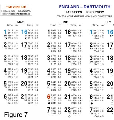
4 Using the tide table on the right, what is the tidal range in the morning of Thursday 19th May?
5 At what time - in British Summer Time - is low water on the morning of Friday 17th June?
6 You anchor in a sheltered bay near Dartmouth just after 4.00 pm (BST) on Saturday 2nd July. What is the minumum depth you should select for anchoring if you want to stay overnight in a boat that draws 1.8m?
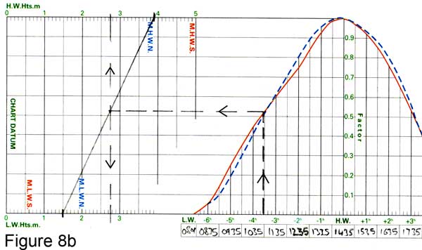
7 The tidal curve above has been marked up with the data for 18th June. Use the blue, dotted, curve as it is close to Neap tides. a) At approximately what time will the height of tide be 2m? b) Roughly what will the height of tide be, 2 hours before High Water?
8 Download the same tidal curve by clicking here.
Using the data for 6th June: a) What is the height of tide at 1250? b) At 1520? c) At 2000? d) Between what times will the height of tide be greater than 2.5m? e) Between what times will the height of tide be greater than 4m?
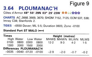 9 On the 23rd July 2008 the tide table entry for St Malo is as follows:
0446 ............ 2.1
1010 ............ 11.2
1658 ............ 2.5
2224 ............ 11.3
What is the corresponding data for Ploumanac'h?
10 On 25th August 2008 the tide table entry for St Malo is as follows:
0200 ............ 9.6
0711 ............ 4.2
1253 ............ 9.4
1956 ............ 4.4
To the nearest 10 minutes and 0.25m, what time and height are the morning low water and midday high water at Ploumanac'h? Estimate this quickly in your head, and after that work out the full day's data accurately.
For these questions, use the tidal diamond data from Admiralty Leisure Folio "The Solent and Approaches" (selected because this Folio will be useful for a lot of people to own). Alternatively you will find similar tidal stream information on other charts of the area, in Tidal Stream Atlases or in the Almanac.
With these chart folios, all the tidal information is usually gathered together on the back of one of the charts (Chart 5600.20 in the case of the 10th Edition of the Solent folio). With full-sized Admiralty charts, tidal data for each of the diamonds is printed in a table on the front of the individual chart.
1 Tidal diamond D is at a position four miles south of St Catherine's point (chart 5600.1). At this position, what is the tidal stream 3 hours after HW Portsmouth (spring tides)?
2 At the same point what is the tidal stream 5 hours before HW Portsmouth (neap tides)?
3 You fix your position at 50 32.1 North 001 44.3 West at 1130 BST on Thursday 24th July 2008. What estimate of tidal stream would you use to construct an EP over the following hour? (The tides are about half way between spring and neap, and see question 5 for tide table).
4 Compare the tidal streams at D with those at tidal diamond B, some 16 miles south of the coast at Christchurch. What do you notice about a) the direction and b) the speed of the tidal streams at the two positions? Looking at the "big picture", what do you make of the comparison: can you explain it?
5 Taking diamonds B, D and G as representative of what my be happening more generally in the English Channel to the south of the Isle of Wight, work out the times of the East-going (flood tide) and West-going (ebb tide) streams in this area on Thursday 24th July 2008. The entry in the Portsmouth tide table is as follows:
0233 ................. 4.4
0809 ................. 1.1
1507 ................. 4.5
2034 ................. 1.2
6 Look at the tidal diamonds in the Western Solent and the Needles Channel. You plan some gentle day sailing in the area. At what times do the west-going and east-going tidal streams begin on Saturday 21st June 2008? The entry in the Portsmouth tide table is:
0022 ................. 4.4
0603 ................. 1.1
1255 ................. 4.4
1819 ................. 1.3
7 Looking generally at the Western Solent (look at 5600.1 showing the whole of the Solent and Isle of Wight), where would you expect the west-going stream to be strongest and why? Confirm whether this is the case by looking at the tidal diamond data.
8 On Saturday 13th September 2008 you plan to sail round the outside of the Isle of Wight with some friends, starting from the Hamble. Assuming that you can sail at least 5 knots, make a plan for the passage so that you make the best use of the tides. HW Portsmouth is at 0959 and 2206 UT.
Answers
Explanation of Tides: 1 False. The sun does have a greater mass, but the moon has more effect on tides because it is closer; 2 False. The sun does have an effect - either reinforcing or counteracting the effect of the moon; 3 Two tidal cycles (i.e.two high waters and two low waters) in each 24 hour period; 4 True; 5 New moon and full moon; 6 One week; 7 b) is true, the other two are false.
Tidal Heights: 1 a) 6.7m (2.6 + 4.1)
b) 4.1m, at Lowest Astronomical Tide; 2 3.2m (1.4 to cover the mud, plus 1.8 for the boat to float); 3 After 1120, and before 1730.
Tide needs to be half way up, so you can arrive approx half way between low and high water and depart approx half way between high and low - but leave earlier or you may get stuck; 4 2.2m; 5 8.01am; 6 4.3m minimum (and leave a bit of extra margin).
You are arriving at approximately high water and the total drop (to the following morning's low water) is 2.5m; 7 a) 0945 UT b) 3.4m; 8 a) 1.8m b) 3.4m c) 3.6m d) between 1345 and 2110 UT e) between 1620 and 1930 UT; 9 0333 1.8 -
0932 8.6 - 1546 2.1 -
2148 8.7; 10 Approx answer: LW 1 hour earlier (ten past six), HW 35 mins earlier(twenty past twelve); and as it's neaps, LW height 0.7m less (3.5m), HW height 2m less (7.5m).
Accurate data:
0124 7.5 -
0608 3.5 -
1218 7.4 -
1856 3.7
Tidal Streams: 1 4.1 knots direction 276°; 2 1.8 knots direction 100°; 3 Time period is 1030 - 1130 UT, which is 4.5 to 3.5 hours before HW Portsmouth, so use 4 hours before as average. Tide at B is 088 2.1; at C it's 086 1.5, so take the mean value: direction 087° speed 1.8 knots; 4 Apart from small differences in direction, the general flow is "east" or "west" at exactly the same times in both locations: reflecting the general flow east or west in this part of the Engish Channel. Streams are generally faster at location D - presumably because it is close to the prominent headland (St Catherine's Point) sticking out into the channel, which the tide has to flow round; whereas B is opposite a bay; 5 E-going till about 0130; W-going 0230 - 0730; E-going 0830 - 1400; W-going 1500 - 2000; E-going from 2100;all times UT (as in Tide Table); 6 In West Solent, W-going starts 1 hour before HW Portsmouth, E-going starts 5 hours after HW. So the morning tide is East-going, turning West at around 1pm , and East again at 7pm. (Times BST.) At the Needles the streams change about an hour later; 7 The narrowest part of the Western Solent is off Hurst Point, and since the same volume of water has to move through there, it will be travelling faster. Tidal diamonds confirm this, with spring rates up around 4 knots; 8 Go clockwise, and you get 6 hours of favourable daytime tide round the outside of the Island. You want to be off Bembridge turning to the west at about 1000 UT when the west-going tide starts. You should make it to the Needles by 1600 UT when the tide turns to the East and in your favour for entry through the Needles Channel. So leave the Hamble River around 0630 UT and you should have favourable tides to get you down the Eastern Solent.