5.2 Local Weather - How it Works
What is "Local Weather"?
The basic human instinct seems to be to listen to the forecast or look outside, decide if it's cold wet or windy (or going to be), put on the appropriate clothing and get on with the day - without worrying too much about what is causing the weather.
In this section and the next, I want to lead you gently away from that, because understanding what is happening can a) give you get a great deal of satisfaction and b) be very useful: it gives you an insight, for example, into what might happen next, and how sudden that change might be.
Some weather effects are confined to a very small area, say less than five miles. This makes it hard for weather forecasters to provide the service we want. Even if they could predict exactly what is going to happen everywhere, how would they tell people? A forecast for a single county on a showery day would last about five hours. Instead they say things like "a 60% chance of rain", and we all grumble that with all this technology they can't even tell us if we're going to get wet or not.
This section concentrates on the local events and variations in the weather that have particular relevance to seafarers. It pays to understand and observe these, partly because of the difficulty in forcasting them and partly because when you can see what's going on, you don't need to rely on the forecast anyway.
The next section describes the wide area weather "systems", organised weather machines that measure hundreds (sometimes thousands) of miles across.
As we are not concerned with world-wide climate and weather in this chapter, the choice of weather features and the explanations are mostly "UK-oriented" (although a lot of it is relevant all over the world anyway).
Basic physics
At the risk of sounding preachy, it is a great deal easier to understand some aspects of how the weather works if you first understand how its constituent parts - air and water - behave. To keep it simple, I will list 8 facts about them with fairly minimal explanation about why they happen.
Armed just with these facts, you should find it easier to understand the local weather phenomena explained in this section.
1 Wind is the movement of air. Air is a fluid, and as it flows over the surface of the earth it behaves just like a fluid in motion. It is a thousand times less dense than water, but just the same it has to flow up over and round obstacles, and can get quite turbulent when it flows round sharp corners, especially if it is moving fast.
2 Land surface is warmed by the sun, and this heats the air just above it. When the sun goes, the land cools down again, and that cools the air just above it.
3 Sea heats up and cools down too, but much more slowly than land.
4 Warm air rises. When air is warmed up it becomes less dense. This means it will "float" upwards through colder, more dense air. This is called convection. Similarly, cold air sinks.
5 Air expands as it rises - and as it expands, it cools itself. This is because the pressure is less the higher you go (and that, in turn, is because when you go higher there is less weight of air above you, pressing down).
6 Water vapour is water in the form of a gas. Water doesn't need to be at boiling temperature to form a gas. Water vapour is mixed in with air virtually all the time (although the amount varies considerably), and is completely transparent (i.e. invisible). (Boiling is when all the liquid water turns into a gas.)
7 Warm air is able to contain more water vapour than cold air. When warm air containing lots of water is cooled down, it gets to the point where the air can't hold all the water vapour any more. The water then condenses to form droplets which you can see. Cloud and fog are made of these droplets.
8 You need heat energy to turn liquid water into water vapour. When the water vapour condenses back to liquid, you get the energy back in the form of heat.
Local Weather Features
The following sections explain what is happening in a number of different weather features, all of which can be regarded as "local weather" and all relevant to the seafarer because they involve wind and/or visibility.
I will explain each one in terms of the eight "physics facts" listed above.
Wind Affected by Land
As stated above, wind is air flowing, like a fluid. It's not surprising therefore that it behaves the way you would imagine a fluid would when flowing close to obstacles. But we have a tendency not to realise that when we are affected by, say, gusty wind or stronger wind in a particular location: we just think the wind's got up a bit.
Shelter and Gusty Conditions
If you sail far out to sea, the wind is surprisingly steady. It usually changes strength and direction quite gradually. This is also the case when sailing closer to land, if the wind is blowing in from the sea or along the coast.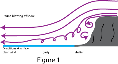
If it is blowing off the land, however, it is a different matter. Say you are sailing close to a large piece of high land on a fairly windy day, as in Figure 1. Close in, you are sheltered - people are playing on the beach and it's lovely. A little further out, and you start to experience gusty conditions - sailing small boats is a little more difficult, and anyone who set out from the beach without thinking about the conditions might get into difficulty. Further out still, and you experience the "true" wind: steadier now, but quite strong because you aren't getting and shelter from the land.
You are still benefitting from the land's presence however. The waves are quite small, because the distance over which this stronger wind is acting (known as the fetch) is also quite small. But as you go further away from the land, the waves get bigger.
All of this is blindingly obvious if you think about what the wind is doing. But it is amazing (and can easily lead to tragedy) how many people just think what a nice day it is, and launch unsuitable craft from beaches in strong offshore wind conditions. The trap is that as soon as you realise what the conditions are really like, you may not be able to get back. Conditions may look lovely when viewed from the shore, but a glance up at the clouds racing through the sky, or the trees at the top of the hill, will tell you what is really going on in the open sea.
Even if you are properly equipped in an offshore vessel, the gust conditions can catch you out, and you may need to anticipate them by reducing sail. (The trick is to look at the sea ahead of you - you can see the wind hitting the sea and making an area of white waves.)
Exposed Headlands and Wind Acceleration
This is also easy to understand. If you have a large bit of land sticking out into the sea (headland) and the wind is blowing, the air can't go through it. It has to go over it or round it (see Figure 2).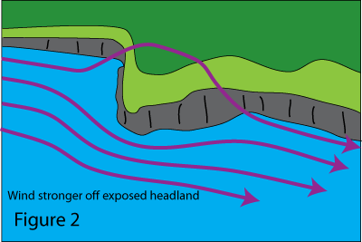
This means that offshore, more air has to get past and therefore you experience stronger winds.
Weather forecasts almost invariably tell you that stronger winds are expected "near exposed headlands", and basically this is a statement of the obvious (they might as well say "light winds in sheltered areas").
You can get a more pronounced version of this when sailing between two islands. The air has to squeeze past both islands, which results in stronger wind between them.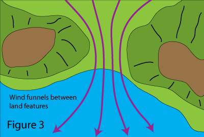
Similarly you can get a valley, or gap between two mountains, which has the same effect and channels the air producing stronger winds in one particular area. If you are sailing though such an area the wind can increase very suddenly indeed, and decrease just as suddenly when you leave it. See Figure 3.
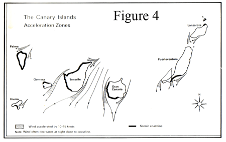 In a particular locality this effect will be well known. Areas which are prone to stronger winds because of this are called acceleration zones, and may be charted in pilot books. Figure 4 shows the acceleration zones around the Canary Islands, and the notes warn you about how strong and local they can be.
But even if you don't have written information or "local knowledge", you can very often predict where to expect stronger conditions by visualising how the air is going to flow past the land when the wind is in a particular direction. You can also see the sea conditions changing - something to observe on a cliff-top walk on a windy day, and build up your own local knowledge.
Thermal Effects
So far we have explained quite a lot of wind phenomena just by thinking about how the air flows past land features. But there are other wind effects which are caused by local heating and cooling of the air.
In a harbour, first thing in the morning on a summer's day, there is very often not a breath of wind. The weather forecast said force 4 to 5, but you can hardly believe that as you drink your tea in the warm sun. You plan to use your largest sails, and anticipate very light winds.
Then around 8.30, you start to feel very light puffs of wind. By 9.30 there is a steady breeze, perhaps a bit irregular because of the surrounding land. When you get out to sea there is quite a strong breeze and you wisely reef the sails.
This is very typical - so what's going on?
The answer is quite simple. The wind is in fact constant, and is blowing as forecast - a few hundred feet above the ground. But down at ground level, and especially in a valley (where harbours tend to be) the ground has cooled down over night. 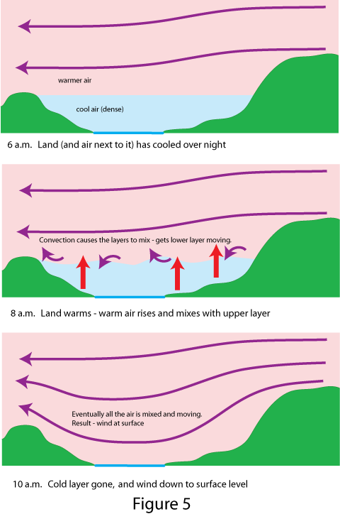 This has cooled the air next to it, so by early morning you have a settled blanket of cool air next to the ground and pooling in the valleys, not going anywhere because nothing is pushing it along. The cool air stays at ground level because it is more dense than the warmer air slipping along above it (this upper air is propelled by the wide area atmospheric pressure gradient - explained in the next section).
Gradually things change. The sun gets up and warms the land, which warms the air next to it. This air becomes less dense and rises, and after a while the air next to the ground starts to generally mix with the upper air. This mixing results in all the air being pushed along by the wind at higher level, and before long you experience a breeze right down to ground level (although there may still be some local shelter).
As the land cools again in the evening the cooler air settles into the valleys, and (to someone observing it on the ground) the wind drops - even though it may still be blowing strongly a few hundred feet up in the air.
Sea Breezes and Land Breezes
A Sea Breeze is something that typically occurs on warm sunny days, starting around mid morning and subsiding in the late afternoon.
It happens independently of any other wind that is being caused by wide area pressure gradients, so I will describe what happens when there is no other wind. As the sun gets higher in the sky, the land warms up. The air immediately above the land warms, becomes buoyant and rises up.
Over the sea, however, no such warming occurs, because the sea barely warms up at all with the action of the sun - the air close to the sea remains cool and dense. 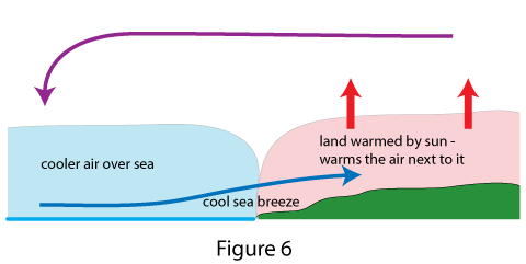
But near the coast, the upward movement of air over the land has the effect of drawing cooler air in from the sea. This in turn warms and rises and draws more cool air in from the sea and so on.
This action generates a "cell" of circulating air: the sea breeze coming onshore from the sea, warm air rising over the land and then moving out over the sea again to replace the air being drawn in on sea breeze. See Figure 6.
If there is a light general wind in the first place, the sea breeze simply adds to it. So if the day starts with a light on-shore wind, this will get stronger and the sea breeze kicks in: 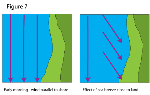 or an offshore wind will die away, and perhaps be reversed, by the stronger sea breeze. Well away from the coast the general wind, caused by pressure gradients over a wide area, will blow unaffected by the coastal sea breeze.
At night the opposite occurs - called a land breeze - but this is generally lighter. Air cools down close to the cooling land, and as it subsides, it flows out over the warmer sea. Here it is warmed, and it rises up, to be drawn back over the land to complete the circulation. Someone sailing a short distance from the land will feel a breeze coming off it - hence the name.
Both the sea breeze and land breeze are predictable and very useful to sailors - on a hot sunny day the sea breeze can be the only source of wind.
Katabatic Wind
Another effect occurs when air cools on high ground, and because it is more dense "flows" down hill. In some localities, because of the way the land channels the flowing air, you can get quite a strong wind, and it generally occurs at predictable times of day e.g. the evening or night when the land is cooling down rapidly after a hot day.
This is called a katabatic wind, and is quite common in areas of the Mediterranian where you get warm weather and mountains near the sea. The localities where this happens are generally well known and may be mentioned in pilot books.
Cumulus Clouds and Rain Showers
So far we haven't needed any water vapour to cause the phenomena we've been discussing, but clouds and rain showers are caused by water vapour, so we draw on a few more of our ten physics facts to explain them.
This chapter is not a full account of every kind of weather, but rather an explanation of a selection of weather phenomena that particularly affect yachtsmen. One such is a shower, not just because we get wet in it, but because a heavy one can cause strong local wind and poor visibility, and occasionally other phenomena: lightning, hail, even tornadoes. In other words quite dangerous and destructive phenomena, so worth understanding.
It all starts with the thermal effect mentioned above. On a sunny day the land is warmed up, and with it the air immediately above it. This air starts to rise.
Now as air rises, it expands (because of the lower pressure around it) and this expansion actually takes energy out of the air, so it cools (physics fact 5, above). Because of this fact, you expect that the further you go up, the cooler the air is. This is, indeed, generally true, but the rate at which the air gets cooler with height does vary from day to day and place to place - depending on the weather.
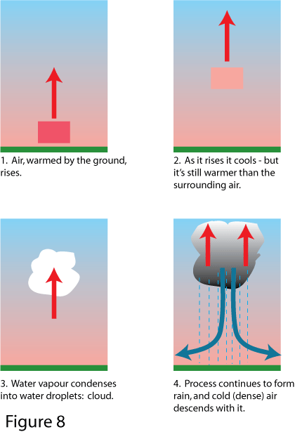 Go back to our "parcel" of rising air. It starts off by being warmed a bit more than the air surrounding it, so it becomes less dense than that air and floats upwards. By the time it gets to 100 feet (say) it has cooled itself slightly. If it is now the same temperature or cooler than the air surrounding it, it stops - because it is no longer any more buoyant than the air around it. BUT if, even having cooled a bit, it is STILL warmer than the surrounding air (as in Figure 8), it goes on rising.
In other words, if the upper air is "cooler than it ought to be", there is nothing to stop our parcel of slightly warmer air rising and rising. (This is known as an unstable atmosphere, and it is quite common during and after the passage of a cold front - see section 4.)
The next thing that happens is that as it rises, our parcel of air (which naturally contains some water vapour) cools to a point where it can no longer hold all the water vapour it originally contained (physics fact 7). The water condenses, forming visible droplets - a cloud. When this happens our parcel of air gets a bit more energy from the condensing water (physics fact 8), which actually helps to stay a bit warmer. So if the surrounding air is STILL cooler than it is, it goes on rising, and the energy from the condensing water helps it on its way.
The cloud, incidentally, is of the white detached type called cumulus.
In practice, what happens next can go one of three ways.
• on a fine day, with a stable atmosphere, the rising air encounters a layer of warmer air at altitude, and the convection process stops. Result: typical, fair weather, fluffy white clouds, which generally appear during fine mornings over land, due to the process described. (You can observe that they don't appear over the sea. This is because the surface of the sea does not heat up like the land, so the convection process doesn't get started.)
• if the warm rising air is only slightly warmer than the surrounding air, the process continues fairly gently, until so much water vapour condenses that it forms into droplets and it starts raining. You get a relatively gentle shower.
• if the upper air is very cold compared to the warm rising air, the process continues and accelerates. You get tall, towering clouds - now described as cumulonimbus or Cb - "boiling" up into the upper atmosphere, and a lot of rain starts being produced. You can also get hail, when the rain freezes in sub-zero air at altitude, and lightning (and consequently thunder) if the air currents in the cloud get violent enough. This weather can reach the extreme end of the spectrum, producing violent winds and rain, even tornados. In the tropics, over very warm water, it is this activity that provides the conditions for generating tropical revolving storms.
Fluffy white clouds and gentle showers present little problem to the sailor, but BBCs (Big Black Clouds) are another matter, particularly if you see dense rain or hail beneath them. A heavy shower often drags down a large quantity of cold air with the rain (with all this warm air rising, the cold air has to go somewhere). This produces a strong vertical wind, which spreads out radially when it hits the surface. 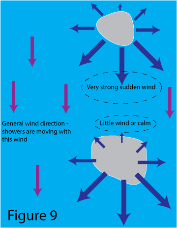
The strength of wind you experience depends on where the centre of the rain storm is, in relation to the "normal" (gradient) wind: if the shower is directly up-wind of you, the extra wind out of the shower will add to the wind: as the shower blows past you the local wind it generates can affect the wind direction, and once down-wind it will tend to cancel out the general wind.
This can sometimes lead to a false impression that the wind has completely dropped once the shower has passed and it's bright and sunny again. Wait a bit, and observe how fast the clouds are moving, before you decide to put up full sail. Once the shower has moved away far enough you get the general wind back (often a brisk breeze), and the next shower will give you strong wind conditions as it approaches - often very suddenly.
Fog
Fog is the same thing as cloud, i.e. water droplets in the air which scatter the light - so unlike invisible water vapour, you can see fog or cloud, and you can't see through it.
Fog is when you get this forming at ground or sea level, and the obvious problem (whether you are on land or at sea) is loss of visibility. This came up in the previous section, because fog is a considerable danger to seafarers: primarily because it hugely increases the dangers of collision, but also because it makes navigation difficult.
Water droplets form when air containing water vapour cools down to the point where it can no longer hold all the water vapour it contains. The water then condenses into droplets. So far in this chapter we have described this happening when air rises, and consequently cools. Obviously this will result in droplets forming well away from the surface, i.e. cloud not fog. So what can cause air to cool at surface level?
The answer is, the surface itself. Fog forms when one of two things happens:
• warm air containing a lot of water vapour flows over a cold surface (either cold sea or cold land)
• warm air containing water vapour is cooled when the surface beneath it cools
(There is a third possibility: warm air being cooled by flowing up hill, but that doesn't happen at sea!)
Either way it is the same fog - but the two mechanisms of formation mean that they tend to happen in different circumstances and in different places.
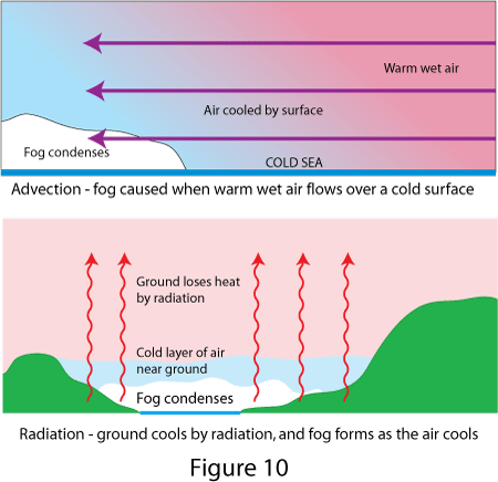 The first is called advection fog, which means nothing more than that the air is "moving to" the place where the fog forms. Significantly for seafarers, at certain times of year in certain geographical areas, the cold surface can quite often be cold sea water. Fog forms when warm air, with lots of water vapour in it, blows over an area of cold sea. In the UK in spring and early summer we are quite used to cold sea, and to winds which are a) warm and b) laden with water vapour, because they have arrived from the warmer ocean to the south west.
The second mechanism is called radiation fog, because radiation is the means by which the surface can cool down quickly. We mentioned a few times above that the ground warms up during the day and cools down at night. The cooling happens because the ground radiates heat, and happens to a much greater extent if the sky is clear (clouds reflect the radiated heat and act like a blanket).
We're quite used to this phenomenon, especially during fair weather in the winter. A couldless starry sky at night results in frost and, more often than not, fog in the morning. The point to note is that this is esentially a land phenomenon, because the sea doesn't cool down nearly as much over night. So if your port of departure is affected by radiation fog forming overnight, the chances are that it will be clear out at sea.