1.5 Position lines
There are a number of other ways to work out your position that do not involve electronics. Practically all of these involve drawing a line on the chart, such that you know you are somewhere on that line. This is called a position line.
If you can draw two or more that intersect, you have a position fix. However you measure and draw your position lines, there are likely to be some inaccuracies or errors - this is absolutely inevitable with practical navigation. 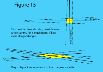
But by choosing position lines well, the effect of the errors can be reduced. The best position fix is obtained from position lines that intersect at a good angle, ideally 60° to 90°. If they intersect at a narrow angle, any errors you have made in drawing the position lines can result in quite a large uncertainty of position (see figure 15).
Three Bearing Fix
By far the most common and useful of these fixes is the three bearing fix, which is derived from measuring the direction or bearing of two or more charted objects that you can identify and see:
• you take a careful measurement of the bearing of each object, using a hand-held compass
• you then adjust the magnetic bearing by the magnetic variation to get the true bearing (subtract westerly variation or add easterly) 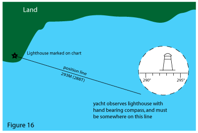
• you then draw a line on the chart through the charted object at exactly the bearing measured (see figure 16)
• this is your position line for that object (we know we must be somewhere on that line in order to measure that bearing).
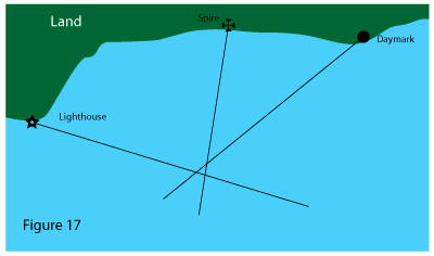
This is repeated for another object, and where the two cross is our position fix, subject to errors of measurement and plotting. If you do the same with a third object the position line should intersect where the other two intersect. In practice it will not quite, because of the errors. Instead the three lines will form a small triangle, known in the trade as a cocked hat (although this is now a seriously outdated metaphor).
As long as the triangle is nice and small you can be confident that you have a good position fix. See figure 17.
If the triangle is very large, it is likely that you have made a mistake or gross error in the process. One of the position lines must be wrong, so start by checking that you have plotted the lines right, then make sure that the measurements were OK, and check your conversions from magnetic to true (it really helps if you write everything down, so that you - or someone else - can check it later).
Finally, check that you were sighting the objects that you identified on the chart. The latter point is very often the most likely and most confusing error (see figure 18).
You may be able to do a fourth position line to see which one of the first three was wrong.

Remember: if you had only done two position lines in the first place you might never have noticed this gross error. This illustrates the "golden rule" of navigation, which is that you WILL make mistakes, so ALWAYS try to check one thing against another: e.g. does your position fix make sense, given your logged distance from your last known position?
Other Position Lines
There are several other ways of getting position lines, and where any two or more intersect at a good angle you can fix your position.
Distance Off
If you can determine your distance off, i.e. the distance between your vessel and a landmark which is marked on the chart, you can draw part of a circle using the landmark as the centre - this is a position line.
A radar can give you the distance from land. The distance can also be determined by measuring the vertical angle of an object above the horizon.
Vertical angles can be measured with a sextant, and the almanac has tables for working out the distance off. This is a less frequently used method.
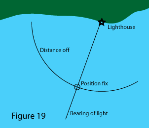
Or you may be able to see a lighthouse just appearing above the horizon. The last one is of particular interest because lighthouses are always marked on the chart, they are easy to identify by their light characteristics, and the rising and dipping of a light is simple to observe in clear conditions; you can just see the clear light as it rises above the horizon and the loom when it dips below.
The nautical almanac has a table for distance off when rising or dipping. You need to estimate the height of your own eye above sea level, and also the height of the light - which will be marked on the chart and for which you should allow for height of tide if you want to be precise.
Figure 19 illustrates this.
If you take a bearing on the light at the same time, this will give you two position lines crossing at rightangles - potentially a good fix. You must make sure you have identified the light correctly, though, and another position line from a different source will help to confirm this.
Depth Contours
Depths are marked on the chart, and so are underwater contour lines known as depth contours. You can measure depth with the echo sounder, and allowing for the height of tide (explained in Chapter 4) you can tell when you are on the contour line. See figure 20. 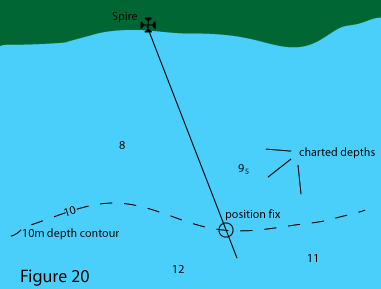
This is a useful technique when the depths are varying in a fairly regular way, on the edge of a channel or shoaling gently towards the land for example. It is not so useful if the sea bed is very irregular - the depth contour lines will be squiggling around all over the place and won’t make such good position lines. Nor is it very useful if the sea bed is almost flat, with the depth changing by a couple of metres in half a mile - it just won’t give you a very accurate position line in that case.
Transits
This is one of the simplest and most accurate position lines. A transit is when two things you can see line up.
If two objects that are marked on the chart can be seen to line up, you are on a position line that can be drawn through those two objects. See figure 21.
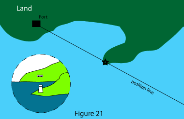
Transits are frequently arranged deliberately, and marked on charts and in pilot books, to guide you into a safe channel or harbour. But you can also spot your own, and if you see a good transit - like two headlands coming into line - it is often worth using it quickly for a position fix.
Note that transits which are "arranged" and charted to guide you into harbour etc should always have a bearing quoted, so that you can check that you have the correct transit marks (the Golden Rule again). And they are always arranged with the further object, or light, higher than the nearer one - if you know this you can work out which way to go to bring them in line.
Sectored Lights 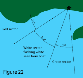
Some lights are arranged so that they shine different colours in different directions. These are called sectored lights, and they and their sectors are marked on the chart. When you see the light as one colour you know you are in that sector (see figure 22 ) and when the light changes from one colour to another you are on the position line that defines the edge of the sectors.
Radio Direction Finding
Some radio receivers are designed so that the aerial can be rotated, and you can tell when it is pointing straight towards the transmitter. This can be used to draw a position line in exactly the same way as when you take a bearing with a hand bearing compass, and is known as radio direction finding.
As an early form of electronic navigation this was quite widely used in the past (and still is in aviation) with radio beacons set up and marked on the chart like radio wave lighthouses. It is less accurate, and now much less widely used, than GPS.
However in an emergency, the Coastguard can give you a position line by listening to your VHF radio transmission from his direction finding aerials (marked on the chart). You can then draw the bearings he gives you onto your chart as position lines.
I heard this used on a foggy morning just after the “week-number roll-over” event on GPS - when a yacht was making landfall after a cross channel trip, and both of his GPS receivers were refusing to work. I also heard it when two of my friends were caught in a sudden gale off Rame Head near Plymouth - they had set out on a beautiful morning (my fault for advising them to go) and the boat being new to them, they hadn't yet got their GPS working...
Horizontal Angle between Objects
This method is seldom used because not all yachts carry sextants and the position line is difficult to plot. If you measure the horizontal angle between two landmarks, it is possible to construct a circle of all the possible positions where that angle between the objects could have been measured, thereby giving a circular position line.
Although it can be very accurate, this is a somewhat cumbersome method of getting a position line.
Astronomical Navigation
Chapter 6 explains that an astro navigation sighting, where you measure the angle above the horizon of the sun, moon, planets or stars and work through the sight reduction procedures, will give you a position line. (It is, in fact, a very large circle but it can be drawn as a straight line for the ten miles or so that you are interested in). So you have to make at least 2 observations to get a position fix.
Transferred Position Lines
This is a very useful method if you can only get one position line - say, a bearing to a known object - and some time later you are able to get another one, perhaps a new bearing to the same object.
By knowing how far you have moved between the two observations you can move, or transfer, the first position line by the same distance and direction that the boat has moved in. Where this transferred position line crosses the new position line, you have a position fix.
Figure 23 illustrates this process.
• at time 1 you measure a bearing and draw a position line 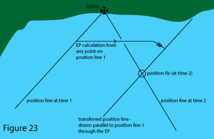
• as you sail along the coast you estimate the movement of the boat using the EP technique - logged distance, leeway and tidal stream
• at time 2 you measure another bearing and draw a second position line
• re-draw the first position line parallel to the original but moved by the same distance and direction the boat has moved in. Just take any point on the first line, work out an EP from that point for time 2, and draw a new line, parallel to the first one, running through that EP
• the fix is where the second position line and the transferred position line intersect.
The method relies on the accuracy with which you can estimate the movement of the boat between the two fixes, hence the accuracy of the log and the tidal estimate are important.
Clearing Lines
Sometimes when navigating you don’t need to know exactly where you are you are. It may be enough to know approximately where you are, and to be sure that you are clear of dangers.
If you can draw a single position line, like a bearing on an object for example, and know that you are not on the line but to one side of it, this can tell you enough about where you are to keep you out of danger. The line is then called a clearing line, and is shown in figure 24. 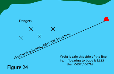
All the methods for getting position lines can also be used for drawing clearing lines; in particular they can be transits, light sectors or bearings on a landmark or navigation mark. Obviously depth contours can also be used to keep away from shallow water dangers.
Clearing lines are one of the best and most useful tools for pilotage (where you are finding your way around close to shore and dangers). One observation can tell you if you are safe or not, which can be far quicker than plotting your position from the GPS.
Another top tip - say you are using a position line which is a bearing to a landmark. If you put that landmark into the GPS as a waypoint, then the GPS can give you the bearing to the landmark - which is a useful back-up (say you can't see the landmark because it's misty) and check of the hand bearing compass observations.