1.1 Position, Speed and Distance
Position
In our normal lives we can use streets and addresses to define where something is. But in an open space we need to be able to define the position of a boat or destination port without reference to roads or landmarks. After that we can work out how to get from one place to another.
The standard way of defining positions is by two angles, latitude and longitude, measured form the centre of the earth, and every position on the surface of the earth can be defined in this way.
(In case you are not familiar with angles, a complete circle is divided into 360 degrees, written 360° - so a quarter circle or "rightangle" is 90°.)
Latitude
Latitude is the angle which defines how far North or South you are.
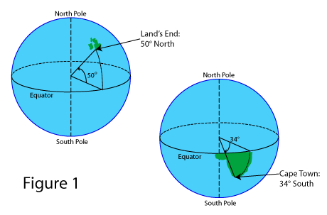
Figure 1 shows how latitude is measured. 
Every point on the surface of the earth has a latitude, and the angle is measured from the equator (0° latitude) to the North Pole in one direction and the South Pole in the other.
The further north or south you are from the equator, the greater the angle. At the limits the North Pole is at 90° North and the South Pole is 90° South. As shown in the diagram, Land’s End is at about 50° North and Cape Town is about 34° South.
Longitude
Longitude defines how far East or West you are.
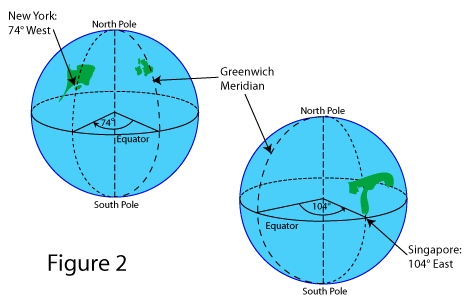
Figure 2 shows how longitude is measured.
We need to measure from a particular point on the earth. With latitude that is the equator, the natural centre line of the earth. With longitude there is no “natural” place to measure from, so we have chosen - somewhat arbitrarily - to measure from Greenwich.
The north-south lines of equal longitude are called meridians (named because mid-day happens simultaneously at all points along each of these lines) so the Greenwich meridian is 0° longitude. Every point on the earth’s surface has a longitude: New York is at about 74° West and Singapore about 104° East. The maximum easterly or westerly longitude is 180° - half way round the world from Greenwich.
Angles
When using latitude and longitude we need to be quite precise about the angle. A full circle is divided into 360° (degrees), hence 90° from the Equator to the Pole. One degree’s difference in latitude is about the distance from Leeds to Newcastle, so for more precise position fixing this needs to be broken down into smaller divisions.
So each degree is divided into 60 minutes (written 60'), and minutes are quoted to as many decimal places as you need.
You can then quote the position of the Bishop Rock light as:
49° 52'.33 North 06° 26'.68 West
and this defines the position to the nearest one hundredth of a minute (0'.01) which is about 20 metres distance on the surface of the earth. This is normally enough precision for navigating at sea. (Historically a minute was divided up into 60 seconds, so 27'.5 was written as 27' 30" , but this is rarely used now - you may see positions quoted in this way in older books, though.)
Plotting Position
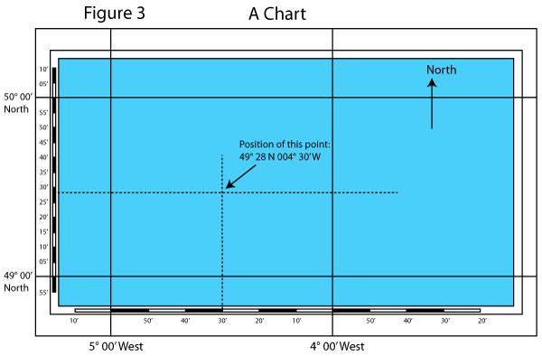
Charts are special maps used for navigation at sea. In order for navigators to be able to see the position of something marked on the chart, or to mark or plot the boat’s position on the chart, latitude and longitude are printed along the chart’s edges.

The chart is printed with North upwards, so latitude (giving North-South position) is marked down the sides of the chart and shows how far up or down the chart you are. Longitude (giving East-West position) is marked along the top and bottom edges and shows how far across the chart you are. Figure 3 shows how this works.
Note that on the bottom of the chart in Figure 3, the numbers - longitude - increase from right to left, which may catch you out - but it's obvious why this is, because the West longitude increases the further West you go. Always check the numbers, or you may get caught out if, say, you've been using a UK West Country chart and you switch to the Med (East Longitudes, increasing from left to right).
Positioning Devices
A number of electronic devices, most notably the Global Positioning System (GPS), give a simple reading of your position in latitude and longitude. These devices and their use in navigation are described later in this chapter.
Other methods of position fixing (also described later) don’t give you latitude and longitude straight away, but enable you to mark your position on the chart. You can then use the markings on the edge of the chart to read off the latitude and longitude of your position.
Distance and Speed
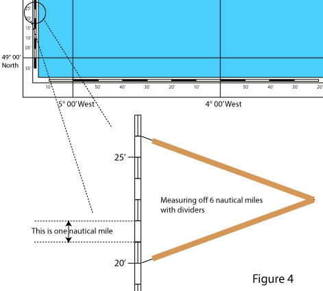
Navigators find it convenient to measure distance using a unit that relates closely to the measurement of position. The unit they use is a nautical mile (also known as “Sea Mile”) and it is defined as one minute (1 sixtieth of a degree) of latitude. This is shown on figure 4.

It is important to remember that this is latitude (on the side of the chart) not longitude (on the top and bottom). The reason for this is that latitude angles give virtually constant distances wherever you are on the earth, but longitude angles do not (because the meridians get closer to each other as you move away from the equator towards the poles as shown in figure 2).
On land we use miles per hour for speed. So at sea speed is measured in nautical miles per hour, known as knots (some people say "knots per hour" but this is rubbish!). To relate these units to something familiar, a nautical mile is about 1.15 statute or “land” miles or 1852 metres. So 20 nautical miles is 23 land miles, and 30mph is 26 knots.
There is one other distance unit that you need to be aware of: a cable is one tenth of a nautical mile, and is just under 200 metres. It is used in pilot books, usually in the context of estimating distance (e.g. "anchor about one and a half cables south of the rocks").
The Log
The log is an instrument on the boat which measures the distance you have travelled through the water, giving a simple reading of nautical miles. From this it can also work out the speed at which you are travelling, displayed in knots. Use of the log is described later.
