Introduction
Seafarers are notoriously affected by the weather, because it can make a huge difference to the conditions we face at sea. With no exaggeration whatever, the weather can turn a really enjoyable family day out in a boat, into a terrifying, extremely uncomfortable, life-threatening situation. It is extremely important that skippers are equipped to make decisions such as whether to go to sea, whether to put in to shelter or whether to carry on.
Added to this, sailors actually rely on one feature of the weather - wind - for their propulsion, so its strength and direction have a great effect on where we can go.
Our main source of information, and defence against being caught out by bad weather, is the weather forecasts provided for mariners. These are more specialised than the general weather forecasts on radio or television broadcasts (which for example rarely mention the direction of the wind). In order to be concise and relevant, forecasts for mariners use a number of terms with specific meanings, and we need to understand those terms in order to benefit from the forecasts.
Besides the forecasts, there is the reality of the weather and the science of what causes it. A small amount of knowledge of this can pay huge dividends when we come to observe what is happening and make decisions accordingly. The later parts of this section attempt to open skippers' eyes to some of the readily observable phenomena of the weather and their physical causes. This observation and understanding makes for better interpretation of weather forecasts.
Weather Forecasts
What we want to know
Mariners need to know slightly different facts about the weather than, say, farmers. We are not particularly interested in quantities of rainfall, or frost, but the following are very important to us:
Wind - its strength and direction. From this we can work out: how rough it is likely to be; how difficult boat handling will be; and where it is likely to be exposed or sheltered. Sailors can also work out how they can sail from A to B (i.e. what point of sail they will be on) and how easy thay journey is likely to be.
Visibility. Apart from rough seas, poor visibility is probably our greatest fear. It makes it harder to see where we are, and harder to see other vessels in order to avoid hitting them. Dive boats may also have difficulty finding their divers, and fishermen their gear.
Sea state. How rough it is, or how big the waves are. This can largely be deduced from wind information, but it may also be susceptible to other factors: swell (large long waves that originate a long way away) and the wind that has been blowing for the last few days, causing the sea state to build up.
General weather. Less important, but it is nice to know whether it's going to rain, and more importantly whether there will be squally showers which generate strong local wind.
Weather (particularly in the UK) is frequently changeable, so we also want to know when the conditions described are likely to apply. We may be interested in longer range forecasts so that we can plan our sailing for the next few days, and finally, to aid our understanding of what is going on, it is helpful to know what wide area weather features are causing our weather, and how they are going to develop.
Sources of Forecasts
The Almanacs, cruising guides and other publications contain up-to-date information on the weather forecasting services available to mariners. Naturally these vary from country to country.
The media by which forecast information can be received moves ever forward with technological development, and now include local and national radio stations, telephone, fax, VHF radio, NAVTEX, "ordinary" internet access, WAP, SMS messages, fax broadcast by HF radio, internet access by satellite, etc etc. It's a good idea to look at any or all of these, to see which ones suit your location, equipment, type of sailing etc. The type of information you get will be very similar in each case (see above), but the forecasts may have originated from different forecasting organisations and therefore may differ.
For ordinary UK coastal sailing I recommend the following (all of which are free):
From home: access the Met Office inshore waters forecast on the internet. This is (currently) a 48 hour forecast updated three times a day, and includes warnings of gales and strong winds.
At the marina or harbour office: a copy of the inshore wates forecast, and/or a dial-up fax from Marinecall (associated with the Met Office), which should give similar information in words, and a chart showing surface pressure and fronts.
At sea: broadcasts from the Coastguard at three-hourly intervals on VHF radio, giving gale and strong wind warnings, inshore waters forecast and (less frequently) the shipping forecast, for the local area. These broadcasts also include new gale warnings which are very important, because they may supersede and invalidate a previous, less severe, weather forecast.
Terms Used & Interpretation
Forecasts need to be clear, concise and precise and therefore certain words that are used in them are given very specific meanings.
Wind
Wind direction is given as the direction the wind is blowing from, which can be a little confusing as other directions we are given - tidal stream for example - are usually the direction something (water, in the tidal stream case) is going to. Also, the directions are usually given in terms of north, south, east and west etc rather than degrees from north (which is the usual modern convention for direction). The reason for this is that forecasts are by their nature approximate, and "north-west" gives a better feel of the approximation than "315". Most people are familiar with this usage, and we are happy to talk about a "north wind" or a "south-east wind".
Changes in wind direction are described using words with specific meanings:
veering means changing in a clockwise direction, e.g. south to west
backing means changing in an anticlockwise direction, e.g. north-west to south-west
cyclonic means considerable change in wind direction as a depression passes through the area (see section 4 on Wide Area Weather for an explanation of this).
Wind strength is generally given in Beaufort Scale. This was developed in 1805 by Admiral Sir Francis Beaufort. Force 0 is calm, and each strength number, increasing from 0 up to 12, corresponds to a range of wind speeds and an observable "look" to the sea. The following table gives the speed (in knots) and term for each force number, together with my own description for sailors.
Force |
Knots |
Term | Description |
|---|---|---|---|
| 0 | less than 1 | calm | glass calm, no sailing! |
| 1 | 1 - 3 | light air | small ripples |
| 2 | 4 - 6 | light breeze | small wavelets |
| 3 | 7 - 10 | gentle breeze | very occasional white wave crest |
| 4 | 11 - 16 | moderate breeze | longer formed waves, some "white horses" |
| 5 | 17 - 21 | fresh breeze | bigger waves, frequent white horses, spray onto boat - reef sails |
| 6 | 22 - 27 | strong breeze | get all reefs in - quite lumpy, especially sailing to windward |
| 7 | 28 - 33 | near gale | uncomfortably large waves, spray begins to be blown in streaks |
| 8 | 34 - 40 | gale | breaking waves blown into well marked streaks |
| 9 | 41 - 47 | strong gale | for yachts, we're now in survival conditions - max wave height 10m |
| 10 | 48 - 55 | storm | max wave height 12.5m |
| 11 | 55 - 63 | violent storm | max wave height 16m |
| 12 | over 64 | hurricane | mean wave heigh exceeds 14m |
Some forecasters use wind speed - in knots, miles per hour of kilometers per hour - instead of Beaufort Scale. You can use the table above to get an idea of the conditions at various windspeeds.
In practice, most people will develop an idea of the wind strengths they would rather avoid. For relatively inexperienced coastal sailing, anything above Force 5 may be difficult to handle, requiring deep reefs and probably involving seasickness. Very few people willingly set out in Gale Force 8 (we may have to deal with a gale at sea, but try to avoid them) and Force 6 to 7 is known (by wise yacht skippers, and rather more disparagingly by professional seamen) as a "yachtsman's gale".
Time
Every forecast has a time when it was issued, which should be noted with the forecast. The following terms then relate to that time:
imminent means within 6 hours of the time of issue
soon means between 6 and 12 hours of the time of issue
later means more than 12 hours from the time of issue
These terms are particularly relevant to Gale and Strong Wind warnings.
Visibility
Visibility is also given using words with specific meanings:
good means more than 5 miles
moderate means between 2 and 5 miles
poor means between 1000m and 2 miles
fog means less than 1000m
Sea State
Again, descriptive terms with specific meanings. The following are the wave heights for the various sea state terms (the height in question refers to the average of the highest 1/3 of the waves, NOT the maximum wave height - which could be very much bigger)
smooth is wave height less than 0.5m
slight is wave height of 0.5m to 1.25m
moderate is wave height of 1.25m to 2.5m
rough is wave height of 2.5m to 4m
very rough is wave height of 4m to 6m
That's enough for us, because above this we are in survival conditions for leisure craft. High, very high and phenominal are used to describe wave heights from 6m to over 14m.
Other Terms
Other terms with specific meanings are used to state the speed at which the barometer is rising or falling at a particular location; and the speed at which a pressure system is moving. These are less important for the average yachtsman, and can be found (along with the ones above) on the Met Office website.
Accuracy of forecasts
Weather forecasting is a complex and inexact science (or art?). Forecasters are gathering large amounts of data and trying to forecast what weather patterns will form, how they will move, and what their characteristics will be (we're talking about wide area weather here - see section 4).
Forecasts have improved over recent years, because the necessary data has become easier to gather, and computers for modelling what is going to happen have become more powerful. But fundamentally, weather is a difficult thing to predict - and impossible to predict to a precision which will satisfy everyone (you know the grumble: "they can't even tell us whether it's going to rain or not", on a day when there is a heavy slow-moving shower in one place and beautiful, fair, sunny conditions 2 miles away).
The following considerations may help when you are trying to work with weather forecasts:
start understanding their language and what's going on. A bit of understanding about weather patterns (section 4) will help you to appreciate what is being described and what is likely to occur at each stage of, say, a frontal passage. You will start to recognise the underlying events driving the weather, so you will still be able to use the forecast even if the weather system's actual progress is a bit quicker or slower than forecast.
don't expect micro-forecasts. On a given day, conditions can be quite different from one locality to the next, and you don't get mile-by-mile forecasts! Understand local weather (section 3), and you will understand some of these differences: it's windier round exposed headlands and calm in sheltered bays! (Not really rocket science, is it??)
the longer range the forecast, the less accurate it will be. Five day forecasts are handy, and will often give you enough accuracy for general planning - but expect the forecast for days 3 to 5 to change quite a lot as they approach, and always get the updated forecast as soon as it becomes available.
sometimes the unexpected happens. With the best will in the world, it can sometimes become apparent that things are not developing as forecast (this is not surprising in a complex weather situation: the data is many hours old by the time the forecast is issued). This can sometimes result, for example, in a gale warning being issued at pretty short notice. In my experience the previous forecast may not be explicitly rescinded - and may even be repeated. I happen to think this is poor procedure, but the important lesson is, listen to the issue times: heed the gale warning, and if it is issued after the "current" forecast, disregard the earlier forecast if it was for more benign weather.
If possible, always get the synoptic chart as well as the narrative forecast. This will help in your education (you get an experienced forecaster's view of the actual conditions that will accompany a particular weather pattern) and will help you to understand the "big picture" - enabling you to cope better if the narrative forecast doesn't seem to be quite accurate.
Local Weather - How it Works
What is "Local Weather"?
The basic human instinct seems to be to listen to the forecast or look outside, decide if it's cold wet or windy (or going to be), put on the appropriate clothing and get on with the day - without worrying too much about what is causing the weather.
In this section and the next, I want to lead you gently away from that, because understanding what is happening can a) give you get a great deal of satisfaction and b) be very useful: it gives you an insight, for example, into what might happen next, and how sudden that change might be.
Some weather effects are confined to a very small area, say less than five miles. This makes it hard for weather forecasters to provide the service we want. Even if they could predict exactly what is going to happen everywhere, how would they tell people? A forecast for a single county on a showery day would last about five hours. Instead they say things like "a 60% chance of rain", and we all grumble that with all this technology they can't even tell us if we're going to get wet or not.
This section concentrates on the local events and variations in the weather that have particular relevance to seafarers. It pays to understand and observe these, partly because of the difficulty in forcasting them and partly because when you can see what's going on, you don't need to rely on the forecast anyway.
Basic physics
At the risk of sounding preachy, it is a great deal easier to understand some aspects of how the weather works if you first understand how its constituent parts - air and water - behave. To keep it simple, I will list 8 facts about them with fairly minimal explanation about why they happen.
Armed just with these facts, you should find it easier to understand the local weather phenomena explained in this section.
1 Wind is the movement of air. Air is a fluid, and as it flows over the surface of the earth it behaves just like a fluid in motion. It is a thousand times less dense than water, but just the same it has to flow up over and round obstacles, and can get quite turbulent when it flows round sharp corners, especially if it is moving fast.
2 Land surface is warmed by the sun, and this heats the air just above it. When the sun goes, the land cools down again, and that cools the air just above it.
3 Sea heats up and cools down too, but much more slowly than land.
4 Warm air rises. When air is warmed up it becomes less dense. This means it will "float" upwards through colder, more dense air. This is called convection. Similarly, cold air sinks.
5 Air expands as it rises - and as it expands, it cools itself. This is because the pressure is less the higher you go (and that, in turn, is because when you go higher there is less weight of air above you, pressing down).
6 Water vapour is water in the form of a gas. Water doesn't need to be at boiling temperature to form a gas. Water vapour is mixed in with air virtually all the time (although the amount varies considerably), and is completely transparent (i.e. invisible). (Boiling is when all the liquid water turns into a gas.)
7 Warm air is able to contain more water vapour than cold air. When warm air containing lots of water is cooled down, it gets to the point where the air can't hold all the water vapour any more. The water then condenses to form droplets which you can see. Cloud and fog are made of these droplets.
8 You need heat energy to turn liquid water into water vapour. When the water vapour condenses back to liquid, you get the energy back in the form of heat.
Local Weather Features
The following sections explain what is happening in a number of different weather features, all of which can be regarded as "local weather" and all relevant to the seafarer because they involve wind and/or visibility.
I will explain each one in terms of the eight "physics facts" listed above.
Wind Affected by Land
As stated above, wind is air flowing, like a fluid. It's not surprising therefore that it behaves the way you would imagine a fluid would when flowing close to obstacles. But we have a tendency not to realise that when we are affected by, say, gusty wind or stronger wind in a particular location: we just think the wind's got up a bit.
Shelter and Gusty Conditions
If you sail far out to sea, the wind is surprisingly steady. It usually changes strength and direction quite gradually. This is also the case when sailing closer to land, if the wind is blowing in from the sea or along the coast.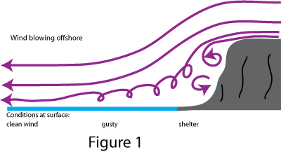
If it is blowing off the land, however, it is a different matter. Say you are sailing close to a large piece of high land on a fairly windy day, as in Figure 1. Close in, you are sheltered - people are playing on the beach and it's lovely. A little further out, and you start to experience gusty conditions - sailing small boats is a little more difficult, and anyone who set out from the beach without thinking about the conditions might get into difficulty. Further out still, and you experience the "true" wind: steadier now, but quite strong because you aren't getting and shelter from the land.
You are still benefitting from the land's presence however. The waves are quite small, because the distance over which this stronger wind is acting (known as the fetch) is also quite small. But as you go further away from the land, the waves get bigger.
All of this is blindingly obvious if you think about what the wind is doing. But it is amazing (and can easily lead to tragedy) how many people just think what a nice day it is, and launch unsuitable craft from beaches in strong offshore wind conditions. The trap is that as soon as you realise what the conditions are really like, you may not be able to get back. Conditions may look lovely when viewed from the shore, but a glance up at the clouds racing through the sky, or the trees at the top of the hill, will tell you what is really going on in the open sea.
Even if you are properly equipped in an offshore vessel, the gust conditions can catch you out, and you may need to anticipate them by reducing sail. (The trick is to look at the sea ahead of you - you can see the wind hitting the sea and making an area of white waves.)
Exposed Headlands and Wind Acceleration
This is also easy to understand. If you have a large bit of land sticking out into the sea (headland) and the wind is blowing, the air can't go through it. It has to go over it or round it (see Figure 2).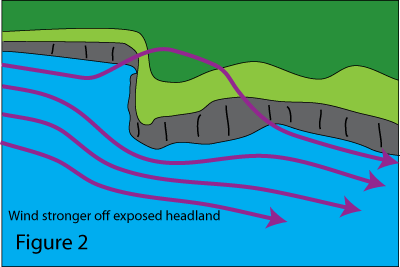
This means that offshore, more air has to get past and therefore you experience stronger winds.
Weather forecasts almost invariably tell you that stronger winds are expected "near exposed headlands", and basically this is a statement of the obvious (they might as well say "light winds in sheltered areas").
You can get a more pronounced version of this when sailing between two islands. The air has to squeeze past both islands, which results in stronger wind between them.
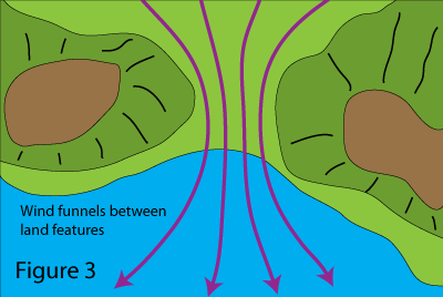 Similarly you can get a valley, or gap between two mountains, which has the same effect and channels the air producing stronger winds in one particular area. If you are sailing though such an area the wind can increase very suddenly indeed, and decrease just as suddenly when you leave it. See Figure 3.
In a particular locality this effect will be well known. Areas which are prone to stronger winds because of this are called acceleration zones, and may be charted in pilot books. Figure 4 shows the acceleration zones around the Canary Islands, and the notes warn you about how strong and local they can be.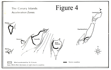
But even if you don't have written information or "local knowledge", you can very often predict where to expect stronger conditions by visualising how the air is going to flow past the land when the wind is in a particular direction. You can also see the sea conditions changing - something to observe on a cliff-top walk on a windy day, and build up your own local knowledge.
Thermal Effects
So far we have explained quite a lot of wind phenomena just by thinking about how the air flows past land features. But there are other wind effects which are caused by local heating and cooling of the air.
In a harbour, first thing in the morning on a summer's day, there is very often not a breath of wind. The weather forecast said force 4 to 5, but you can hardly believe that as you drink your tea in the warm sun. You plan to use your largest sails, and anticipate very light winds.
Then around 8.30, you start to feel very light puffs of wind. By 9.30 there is a steady breeze, perhaps a bit irregular because of the surrounding land. When you get out to sea there is quite a strong breeze and you wisely reef the sails.
This is very typical - so what's going on?
The answer is quite simple. The wind is in fact constant, and is blowing as forecast - a few hundred feet above the ground. But down at ground level, and especially in a valley (where harbours tend to be) the ground has cooled down over night. 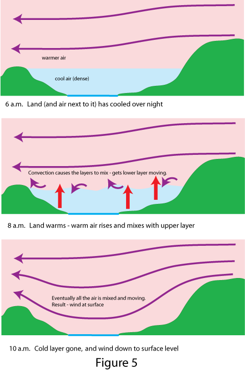 This has cooled the air next to it, so by early morning you have a settled blanket of cool air next to the ground and pooling in the valleys, not going anywhere because nothing is pushing it along. The cool air stays at ground level because it is more dense than the warmer air slipping along above it (this upper air is propelled by the wide area atmospheric pressure gradient - explained in the next section).
Gradually things change. The sun gets up and warms the land, which warms the air next to it. This air becomes less dense and rises, and after a while the air next to the ground starts to generally mix with the upper air. This mixing results in all the air being pushed along by the wind at higher level, and before long you experience a breeze right down to ground level (although there may still be some local shelter).
As the land cools again in the evening the cooler air settles into the valleys, and (to someone observing it on the ground) the wind drops - even though it may still be blowing strongly a few hundred feet up in the air.
Sea Breezes and Land Breezes
A Sea Breeze is something that typically occurs on warm sunny days, starting around mid morning and subsiding in the late afternoon.
It happens independently of any other wind that is being caused by wide area pressure gradients, so I will describe what happens when there is no other wind. As the sun gets higher in the sky, the land warms up. The air immediately above the land warms, becomes buoyant and rises up.
Over the sea, however, no such warming occurs, because the sea barely warms up at all with the action of the sun - the air close to the sea remains cool and dense. 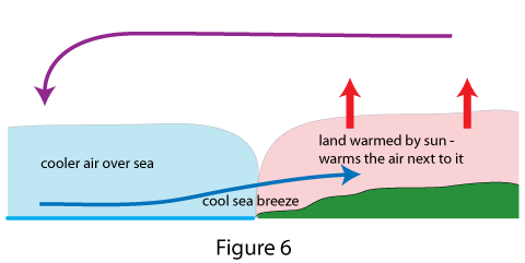
But near the coast, the upward movement of air over the land has the effect of drawing cooler air in from the sea. This in turn warms and rises and draws more cool air in from the sea and so on.
This action generates a "cell" of circulating air: the sea breeze coming onshore from the sea, warm air rising over the land and then moving out over the sea again to replace the air being drawn in on sea breeze. See Figure 6.
If there is a light general wind in the first place, the sea breeze simply adds to it. So if the day starts with a light on-shore wind, this will get stronger and the sea breeze kicks in: 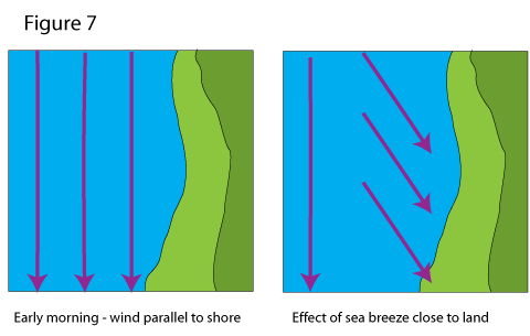 or an offshore wind will die away, and perhaps be reversed, by the stronger sea breeze. Well away from the coast the general wind, caused by pressure gradients over a wide area, will blow unaffected by the coastal sea breeze.
At night the opposite occurs - called a land breeze - but this is generally lighter. Air cools down close to the cooling land, and as it subsides, it flows out over the warmer sea. Here it is warmed, and it rises up, to be drawn back over the land to complete the circulation. Someone sailing a short distance from the land will feel a breeze coming off it - hence the name.
Both the sea breeze and land breeze are predictable and very useful to sailors - on a hot sunny day the sea breeze can be the only source of wind.
Katabatic Wind
Another effect occurs when air cools on high ground, and because it is more dense "flows" down hill. In some localities, because of the way the land channels the flowing air, you can get quite a strong wind, and it generally occurs at predictable times of day e.g. the evening or night when the land is cooling down rapidly after a hot day.
This is called a katabatic wind, and is quite common in areas of the Mediterranian where you get warm weather and mountains near the sea. The localities where this happens are generally well known and may be mentioned in pilot books.
Cumulus Clouds and Rain Showers
So far we haven't needed any water vapour to cause the phenomena we've been discussing, but clouds and rain showers are caused by water vapour, so we draw on a few more of our ten physics facts to explain them.
One of the weather phenomena that particularly affect yachtsmen is a shower; not just because we get wet in it, but because a heavy one can cause strong local wind and poor visibility, and occasionally other phenomena such as lightning, hail, even tornadoes. These can be quite dangerous and destructive phenomena, so worth understanding.
It all starts with the thermal effect mentioned above. On a sunny day the land is warmed up, and with it the air immediately above it. This air starts to rise.
Now as air rises, it expands (because of the lower pressure around it) and this expansion actually takes energy out of the air, so it cools (physics fact 5, above). Because of this fact, you expect that the further you go up, the cooler the air is. This is, indeed, generally true, but the rate at which the air gets cooler with height does vary from day to day and place to place - depending on the weather.
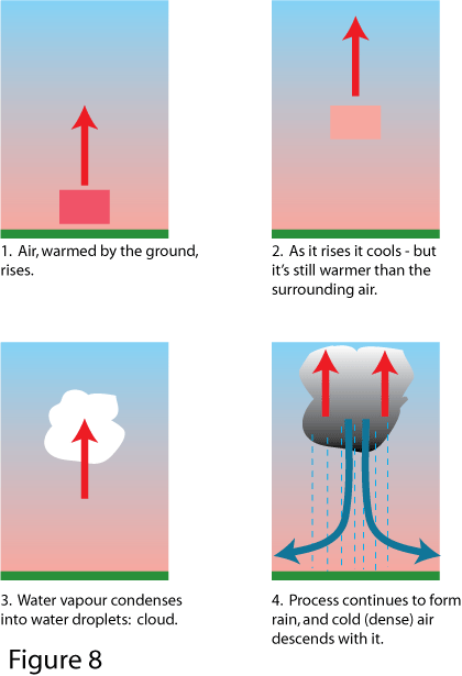 Go back to our "parcel" of rising air. It starts off by being warmed a bit more than the air surrounding it, so it becomes less dense than that air and floats upwards. By the time it gets to 100 feet (say) it has cooled itself slightly. If it is now the same temperature or cooler than the air surrounding it, it stops - because it is no longer any more buoyant than the air around it. BUT if, even having cooled a bit, it is STILL warmer than the surrounding air (as in Figure 8), it goes on rising.
In other words, if the upper air is "cooler than it ought to be", there is nothing to stop our parcel of slightly warmer air rising and rising. (This is known as an unstable atmosphere, and it is quite common during and after the passage of a cold front - see section on Wide Area weather.)
The next thing that happens is that as it rises, our parcel of air (which naturally contains some water vapour) cools to a point where it can no longer hold all the water vapour it originally contained (physics fact 7). The water condenses, forming visible droplets - a cloud. When this happens our parcel of air gets a bit more energy from the condensing water (physics fact 8), which actually helps to stay a bit warmer. So if the surrounding air is STILL cooler than it is, it goes on rising, and the energy from the condensing water helps it on its way.
The cloud, incidentally, is of the white detached type called cumulus.
In practice, what happens next can go one of three ways.
• on a fine day, with a stable atmosphere, the rising air encounters a layer of warmer air at altitude, and the convection process stops. Result: typical, fair weather, fluffy white clouds, which generally appear during fine mornings over land, due to the process described. (You can observe that they don't appear over the sea. This is because the surface of the sea does not heat up like the land, so the convection process doesn't get started.)
• if the warm rising air is only slightly warmer than the surrounding air, the process continues fairly gently, until enough water vapour condenses that it forms into droplets and it starts raining. You get a relatively gentle shower.
• if the upper air is very cold compared to the warm rising air, the process continues and accelerates. You get tall, towering clouds - now described as cumulonimbus or Cb - 'boiling' up into the upper atmosphere, and a lot of rain starts being produced. You can also get hail, when the rain freezes in sub-zero air at altitude, and lightning (and consequently thunder) if the air currents in the cloud get violent enough. This weather can reach the extreme end of the spectrum, producing violent winds and rain, even tornados. In the tropics, over very warm water, it is this activity that provides the conditions for generating tropical revolving storms (hurricanes).
Fluffy white clouds and gentle showers present little problem to the sailor, but BBCs (Big Black Clouds) are another matter, particularly if you see dense rain or hail beneath them. A heavy shower often drags down a large quantity of cold air with the rain (with all this warm air rising, the cold air has to go somewhere). This produces a strong vertical wind, which spreads out radially when it hits the surface. 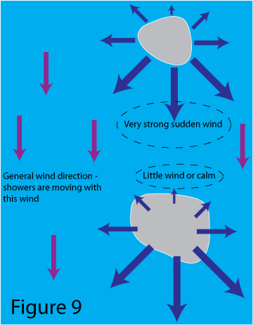
The strength of wind you experience depends on where the centre of the rain storm is, in relation to the general wind: if the shower is directly up-wind of you, the extra wind out of the shower will add to the wind: as the shower blows past you the local wind it generates can affect the wind direction, and once down-wind it will tend to cancel out the general wind.
This can sometimes lead to a false impression that the wind has completely dropped once the shower has passed and it's bright and sunny again. Wait a bit, and observe how fast the clouds are moving, before you decide to put up full sail. Once the shower has moved away far enough you get the general wind back (often a brisk breeze), and the next shower will give you strong wind conditions as it approaches - often very suddenly.
Fog
Fog is the same thing as cloud, i.e. water droplets in the air which scatter the light - so unlike invisible water vapour, you can see fog or cloud, and you can't see through it.
Fog is when you get this forming at ground or sea level, and the obvious problem (whether you are on land or at sea) is loss of visibility. This came up in the previous section, because fog is a considerable danger to seafarers: primarily because it hugely increases the dangers of collision, but also because it makes navigation difficult.
Water droplets form when air containing water vapour cools down to the point where it can no longer hold all the water vapour it contains. The water then condenses into droplets. So far in this chapter we have described this happening when air rises, and consequently cools. Obviously this will result in droplets forming well away from the surface, i.e. cloud not fog. So what can cause air to cool at surface level?
The answer is, the surface itself. Fog forms when one of two things happens:
• warm air containing a lot of water vapour flows over a cold surface (either cold sea or cold land)
• warm air containing water vapour is cooled when the surface beneath it cools
(There is a third possibility: warm air being cooled by flowing up hill, but that doesn't happen at sea!)
Either way it is the same fog - but the two mechanisms of formation mean that they tend to happen in different circumstances and in different places.
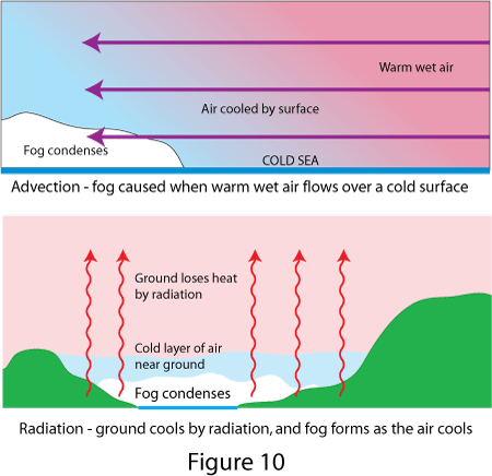 The first is called advection fog, which means nothing more than that the air is "moving to" the place where the fog forms. Significantly for seafarers, at certain times of year in certain geographical areas, the cold surface can quite often be cold sea water. Fog forms when warm air, with lots of water vapour in it, blows over an area of cold sea. In the UK in spring and early summer we are quite used to cold sea, and to winds which are a) warm and b) laden with water vapour, because they have arrived from the warmer ocean to the south west.
The second mechanism is called radiation fog, because radiation is the means by which the surface can cool down quickly. We mentioned a few times above that the ground warms up during the day and cools down at night. The cooling happens because the ground radiates heat, and happens to a much greater extent if the sky is clear (clouds reflect the radiated heat and act like a blanket).
We're quite used to this phenomenon, especially during fair weather in the winter. A cloudless starry sky at night results in frost and, more often than not, fog in the morning. The point to note is that this is esentially a land phenomenon, because the sea doesn't cool down nearly as much over night. So if your port of departure is affected by radiation fog forming overnight, it is quite likely to be clearer out at sea.
Wide Area Weather - How it Works
Wide Area Weather Systems
In the previous section all the phenomena we talked about were 'local', i.e. affecting a relatively small area.
This section describes much larger features and organised weather 'systems', hence the weather forecasters are much more able to observe them and predict their behaviour. The larger features are what drives the general wind, or gradient wind, that we have referred to in the previous section in contrast to the 'local wind'.
A word about why we are interested in this. After all, weather forecasters can tell us predicted wind strengths and directions, can't they?
Well there are a few reasons. First, 'grown up' long range forecasts, weather faxes and so on, use weather maps, and we want to be able to interpret these. Second, if we understand how a weather system works, then we can better interpret what is actually going on in our location. For example, the passage of a front can be very obvious and visible, and when the rain stops and the sun comes out, it would be nice to know what the wind is likely to do. We can also observe the barometer, and if we know what we are looking for, that can give us useful information about what is happening (or is about to happen).
Basic Physics
In addition to the physics facts stated in the previous section, here are two more which have particular relevance to what follows:
9 Water vapour is absorbed by air passing over oceans. Air which passes over continental land is considerably drier.
10 Over a wide area (a hundred miles or more) the pressure or air at the earth's surface can vary, and the air does NOT flow directly from the place of high pressure to the place of low as you might expect. Instead, it spirals round an area of low (or high) pressure (like a giant version of the circulation above the plug hole when the bath water drains out). This circulation is caused by the rotation of the earth, and occurs in the opposite direction in the north and south hemispheres.
The following sections go into that last fact in a little more detail.
Surface Pressure and Isobars
Physics fact 10 mentioned that there is a variation of surface pressure over a wide area. There is a direct link between pressure variation and wind, so it is worth understanding what the link is, and how pressure variations are shown on weather maps.
Surface pressure is measured in milibars - one bar, or 1000mb, being approximately the average pressure of the atmosphere - and the pressure usually ranges between about 960mB and 1040mB. (If you come across hectopascals, this is in fact exactly the same measurement as milibars.) 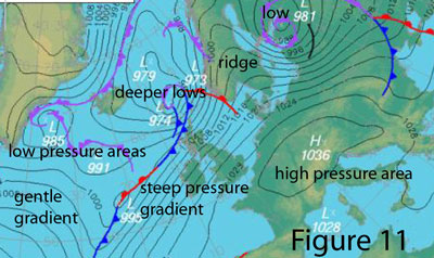
On weather maps or synoptic charts, places of equal pressure are joined together by isobars (the word just means "same pressure"), which show the atmospheric pressure in exactly the same way as contours show the height of the ground. In fact it helps to visualise isobars as 'pressure contours', with dips, valleys, ridges and high areas representing low and high pressure areas instead of low and high ground. Quite a lot of the same terms are used; for example we talk about a pressure gradient in the same way as we refer to the gradient of sloping ground. Figure 11 shows this.
Wind and Isobars
One's initial instinct is to think that air should move straight from a place of high pressure to the place of low pressure and even everything out. But in fact there are two reasons why these pressure differences can exist, and why air in motion will have a pressure gradient at rightangles to the direction of motion - and will not (cannot) move in the direction of the pressure gradient. 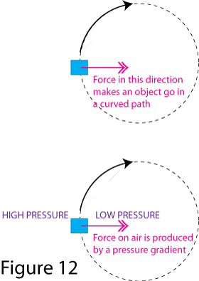
The first applies to air (or any fluid or object) moving in a curve. Anything moving along a curved path is actually accelerating, because its velocity (which means speed AND direction) is changing.
By Newton's laws of motion, a force must be applied at rightangles to the direction of motion to cause this acceleration, and in the case of atmospheric air, this force is the pressure gradient.
(A special case of this is the vortex - constant circular motion round a central low pressure area, just like bath water going down the plug hole.)
See Figure 12.
There are hundreds of examples of this in everyday life: the sideways force you feel when you drive a car round a corner, the force you apply on an object when you swing it around you on a rope, etc.
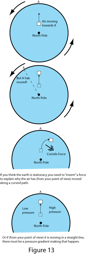 The second is less obvious and applies to any movement of the air on the earth's surface, straight or curved. Because of the rotation of the earth, the air experiences a force called the Coriolis force, at rightangles to the direction of motion. (This force is greater at higher latitudes and negligible near the Equator.)
So if air is moving in a straight line over the earth's surface, then a pressure gradient must exist at rightangles to the direction of motion, to balance the Coriolis force. The Coriolis force acts to the right in the northern hemishere, and to the left in the southern hemisphere.
Coriolis is the force you need to 'invent' to explain motion on a rotating frame of reference - the earth's surface. The earth's surface doesn't seem to us as if it is rotating, which is why we are happy to use it as a stationery frame of reference, and we don't encounter the Coriolis effect every day. But try walking in a straight line on a children's roundabout, and you will get the idea.
See Figure 13.
Fascinating though all this is, that's all the explanation you are going to get here. The important question is, what does this mean in practice?
• the wind blows very nearly parallel to the isobars (angled very slightly towards the low pressure, and more so where surface friction is slowing it down)
• the wind direction is anti-clockwise round a low pressure system, and clockwise round a high pressure area, in the northern hemisphere. "In north latitudes, face the wind and the barometer will be lowest to your right" (Buys Ballot's Law). It goes in the opposite direction in the southern hemisphere. 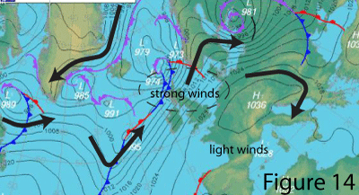
• the greater the pressure gradient, (i.e. the closer the isobars are together) the stronger the wind.
This means that you can look at a weather map and tell from the isobars what the wind strength and direction will be. See Figure 14.
As noted in section 2 on weather forecasts, we have special words to describe the change in direction of the wind, called veering and backing. Veering (sometimes called "clocking") is when the direction from which the wind is blowing changes in a clockwise direction, for example west - northwest - north. Backing is the opposite, e.g. west - southwest - south.
Air Masses and Fronts
A good deal of our weather is caused by the meeting of air masses which have different origins and therefore different characteristics: amount of water vapour contained in them, and temperature (and hence density). Examples are the air mass which has formed over the North American continent, which in winter is cold and dry: and the air mass from the tropical Atlantic ocean, which is warm and contains a large amount of water vapour (i.e. 'wet').
The line along which two such air masses meet is called a front. The military metaphor is well chosen, because there can be quite a bit of 'conflict' between the two air masses - and quite severe weather. This is because the air masses tend to push into each other, and because of the temperature difference, quite a lot of energy is available to generate strong winds and rain.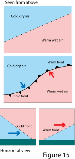
Say you have two air masses pushing into each other (see Figure 15). Where the warm wet air pushes into the cold air, it is called a warm front - and has a special symbol on weather maps. If the cold air is pushing into the warm it is called a cold front.
From the side, the front isn't straight up and down. The cold air is heavier - more dense - than the warm (physics fact 4), so with a warm front the warm air rides up over a wedge of cold air. Similarly the cold air of a cold front pushes underneath the warm air. Consequently, the two fronts have slightly different weather characteristics, described below. Remember, though, that fronts are not always perfect and conditions can depart somewhat from the descriptions in the textbooks (which the weather systems haven't read). The main things to remember are:
• fronts generate stronger winds and rain (the energy comes from the temperature difference between the air masses, so the greater and sharper the difference, the more violent the weather)
• as the front passes you, the wind direction and the air temperature will change: it will get warmer with a warm front, and colder with a cold front, and the wind will normally veer. The barometer will stop falling and/or start rising.
• as the front moves away from you, the wind will normally ease, and the rain cease or become showery.
The sequence of weather as a frontal depression passes you is described in the next section, but it is worth noting here the main differences between warm and cold fronts:
• a warm front is preceded by 100% cloud cover, gradually thickening and getting lower, and drizzle intensifying into heavy rain
• a cold front will generally feature heavy squally rain, followed by heavy showers with clear intervals (and greatly improved visibility).
Atlantic Depression
In the UK, the weather system that causes most of our wind and rain is the Atlantic depression, a frontal low pressure system that forms over the North Atlantic and usually (because of the broader global wind circulation patterns) heads east or northeast towards Europe. (It's sometimes just called a low or Atlantic low.) It is well worth understanding how this weather system works, and how its features are portrayed on weather maps. 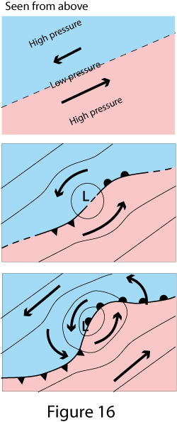
It starts with the two air masses mentioned above. They meet along a line which is typically just off Newfoundland (it moves around a bit). If the warm air to the south is moving north east as shown in Figure 6, and if the cold air is moving more slowly or the other way, conditions are right for a depression to form. There is a pressure gradient associated with this movement, as explained above.
A small wave-like disturbance develops on the frontal boundary between the two air masses. This then starts to circulate (due to the Coriolis effect), and a pressure gradient develops, with low pressure in the middle of the circulating air.
The system now develops and deepens (lower pressure in the middle) and two distinct fronts form as part of the system. The system as a whole moves with the approximate speed and direction of the warm air.
By the time it reaches the UK, the depression typically looks like Figure 17.
The whole sytem is moving. As it tracks across us (for example, suppose the dashed line ABCDE tracks over our position) we experience the following sequence of weather as each of the points marked on the line reaches us.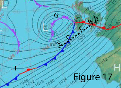
A: warm front approaching. The sky gradually becomes overcast, starting with high clouds and eventually with low grey overcast and drizzle turning to rain. Wind increases and backs.
B: passage of warm front. As it passes and moves away, the wind veers and eases, and the rain stops.
C: warm sector of the depression. Perceptably warmer, with cloudy conditions and perhaps low visibility, occasional light drizzle (the further away from the 'tip' of the warm sector you are, the better the weather conditions)
D: cold front. Wind increases and backs, rain becoming heavier. As the front passes the wind suddenly veers, and temperature falls. Heavy rain continues for a period, and is then replaced by heavy showers with bright intervals.
E: showers become more infrequent and weather fairer. Wind decreases. Good visibility.
Two further things to note: in area F, exactly the same conditions exist that we described for the initial formation of the depression. It is unsurprising, therefore, that a new depression seems to be forming here. This is something to bear in mind when you look at the forecasts: just when you think one depression has cleared past, another forms in its wake! This is called a secondary depression and it can happen several times.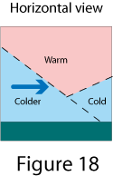
Our system also has a new type of front (see G), called an occlusion or occluded front. This usually forms when a cold front (which often travels faster) catches up with a warm front, and from the side it looks like Figure 18. Needless to say the associated weather is heavy rain!
Sometimes weather forcasters call on our knowledge of these systems (!) when predicting the wind direction. Suppose they predict, for example, that the centre of the depression in Figure 17 is going to track eastwards across the centre of sea area Hebrides. If you happen to be at the northern edge of the area, the low will pass to the south of you, so the wind will be south to begin with, and back: southeast - east - northeast. In contrast, if you are to the south of the area and the centre's track, you will get south or southwest, veering west then northwest. And if you are dead on the track of the centre, you could get an abrupt shift from southerly wind to northerly as it goes through your position. So what is the forecaster to say about the wind direction in sea area Hebrides? Answer: he describes it as cyclonic, which means exactly what I have just described.
Anticyclone
The anticyclone, or High, is an area of high pressure and the weather is a total contrast to the Atlantic depression.
Generally speaking, no fronts are involved (although you will see weather maps where fronts just happen to have ended up in or near areas of high pressure). Generally speaking also, winds are light near the centre of an anticyclone. But the pressure gradients can be quite steep - and the wind consequently quite strong - on the edge of a high pressure area, particularly if there is a deep low pushing into it.
Because there are no fronts the weather is generally fair, and the skies very often clear. Again there can be exceptions, e.g. where thicker cloud is left over from other weather systems, and you can get light rain or drizzle - the weather forecasters often find it quite hard to predict where this will happen. In the winter, the clear skies often result in frost (particularly at night) and fog, and because the air is pretty static you often get haze and smoggy conditions building up with prolonged anticyclonic conditions, until a depression comes along and literally clears the air. 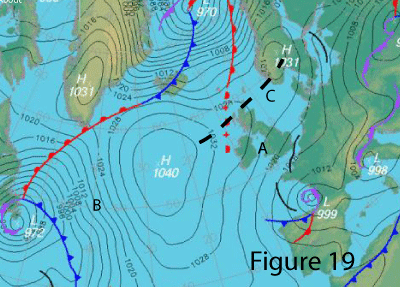
Figure 19 shows an example of an anticyclone. Remember that the wind circulation is still nearly parallel to the isobars, and it is stronger where the isobars are closer together (i.e. the pressure gradient is steeper). Remember also (from the section on wind and isobars) that the wind circulation is clockwise round an anticyclone in the northern hemisphere.
So in area A, you have fair weather with a light north-easterly wind. At B you have fair weather too, but a much stronger south-easterly because of the depression pushing in from the west. The dashed line at C is described as a ridge - an elongated area of high pressure stretching across the north of Scotland to Scandanavia. For logical reasons you often get a ridge extending between two depressions, giving a brief respite of fair weather before the next depression arrives. Note that the Western Isles of Scotland may have a bit of cloud and light rain associated with the end of that warm front.
Conclusion
That describes the main features of wide area weather that you will hear the forecasters talking about.
Incidentally, you may wonder what the short black lines (which aren't marked as fronts) mean on these synoptic charts. A weather forecaster once told me that when they could see a "bit of weather that they couldn't explain", they put a line through it.
There's an example in Figure 11 and three in Figure 19. Short of remembering to take an umbrella, I'm not sure how you are supposed to interpret these ...